
AerialSurveys
What This Charter Is
An aerial survey charter puts a helicopter and crew to work as a data-collection platform. The aircraft carries observers, cameras, or sensors over a defined area or route so that someone on board, or the equipment itself, can record what is below. The deliverable is information, not transportation, so plan the flight the way you would plan any field data acquisition: define the coverage, set the quality spec, and let the flight profile follow from both.
Three mission families are in scope: pipeline and powerline patrol, environmental and wildlife surveys, and mapping or corridor overviews. Patrol means flying a pipeline right-of-way or transmission line looking for leaks, damage, encroachment, or vegetation problems. Environmental and wildlife work covers habitat assessments and population counts, an established use of low-and-slow flying (federal aerial waterfowl surveys, for example). Mapping and corridor overviews deliver current imagery or video of a route, site, or block of land.
Two boundaries up front: creative photo and film production is a different charter with its own page, and lifting anything belongs to the heavy-lift world. Patrol and inspection from the air are in scope here.
One regulatory fact belongs in the project file. Survey missions flown for compensation fall under the same commercial framework as other charters, FAR Part 135, covered in plain English in FAR Part 135 for Charter Customers. A company flying its own aircraft for its own purposes, with no compensation changing hands, may sit under Part 91 instead. Which side of that line your flight falls on is a determination for the operator or your counsel, not an assumption to write into the schedule.
Who Uses It and Why
The clients are surveyors, engineers, utility inspectors, pipeline operators, environmental consultants, agency biologists, and project managers responsible for linear infrastructure or large sites. They share a need to see, count, or document something spread over distance or terrain, on a schedule and at a resolution ground methods cannot deliver.
The helicopter’s case rests on three traits: it flies low and slow enough for an observer or camera to resolve detail, it can hover or re-fly a spot for a second look, and it reaches corridors and terrain with no road access.
How a Typical Flight Works
A survey flight looks nothing like point-to-point charter flying, and the difference drives both the budget and the schedule. A transport charter climbs to cruise altitude, flies a direct line, and descends. A survey flight works the subject: low altitude, slow groundspeed, straight pre-planned lines, turning at the end of each to start the next, often passing over the same corridor or block repeatedly until coverage is complete. Utility patrol follows the line itself, slowing or orbiting at anything that needs inspection.
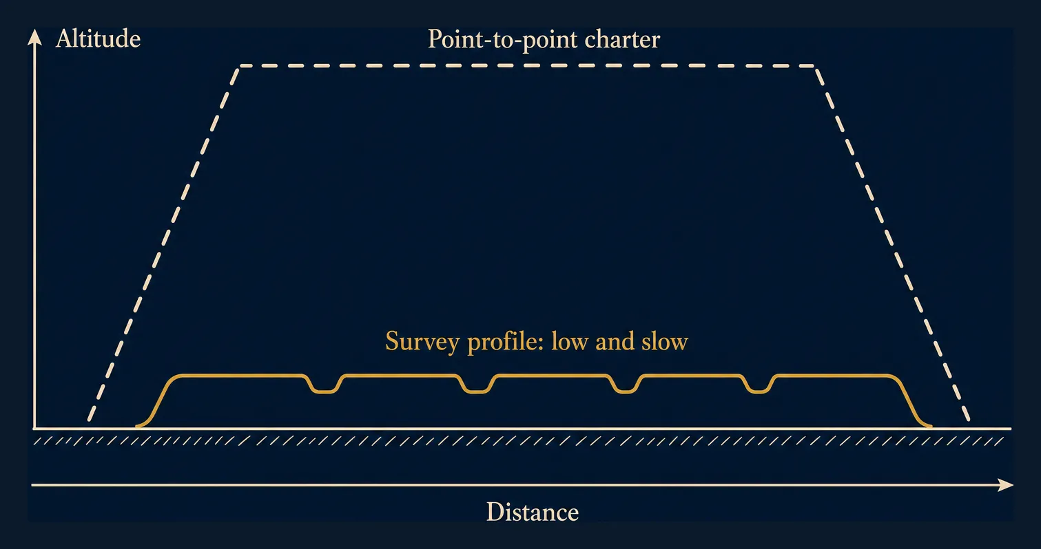
Flight time accumulates by the hour: a modest area can take far longer to cover than a first-time client expects, because coverage, not distance, is the measure. The working altitude is low, so the minimum safe altitude rules in FAR 91.119 and the character of the ground below shape what the pilot can accept. Helicopters have more latitude there than aeroplanes, but the latitude is conditional on the operation posing no hazard to anyone underneath.
Aircraft Typically Used
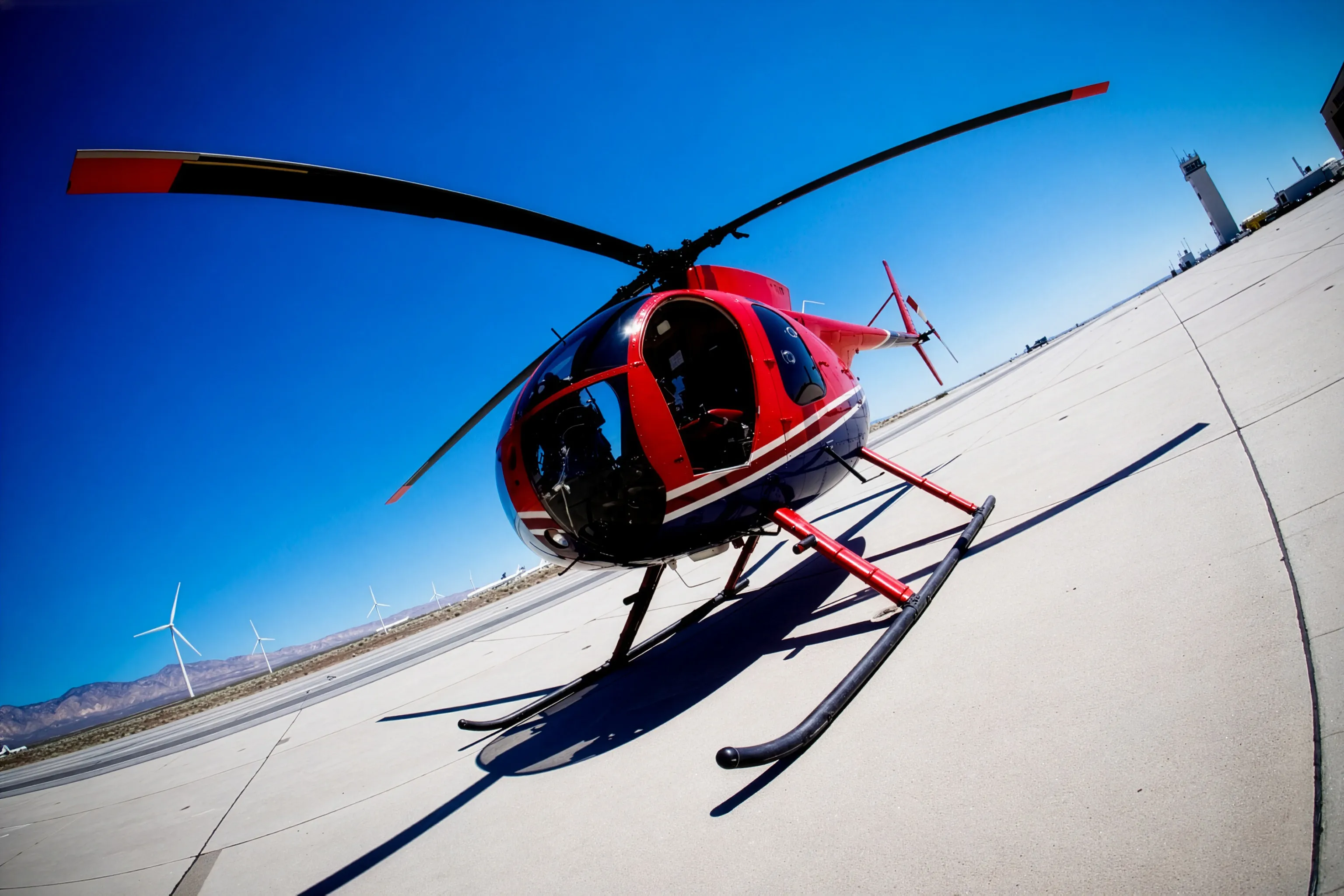
Observer-type survey work is dominated by light single-engine helicopters: the Robinson R44 and R66, the Bell 206 family, and the Airbus H125 family. They are the least expensive helicopters to operate by the hour, offer excellent downward visibility, maneuver well at low speed, and are common in the US fleet.
Twin-engine aircraft enter when the mission demands it: work over water, over congested areas, at night, or under a client or insurer policy requiring two engines. The Helicopter Class Comparison Guide explains the classes in charter terms.
Observers, Sensors, and Equipment
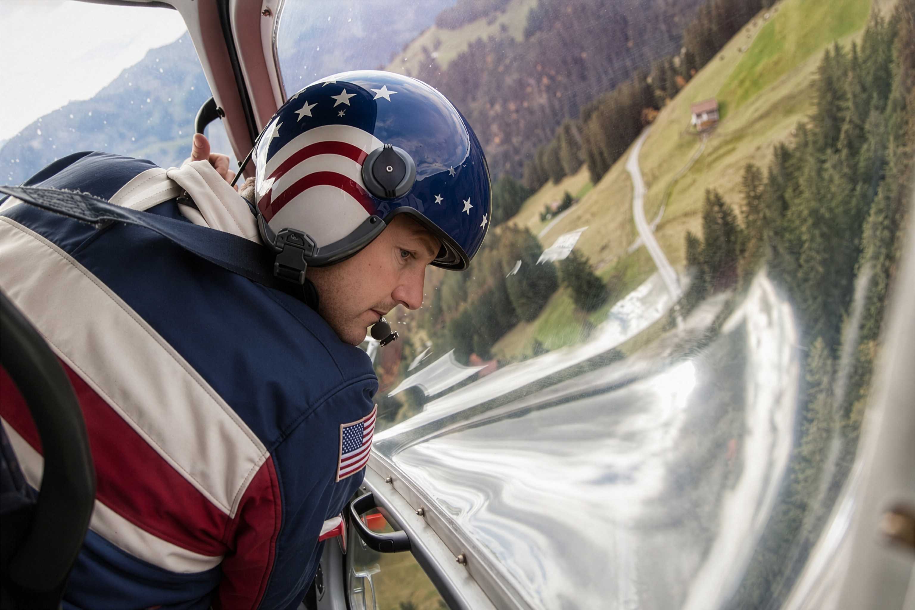
In a light helicopter the observer sits beside the pilot in front or in the rear cabin; the front seat offers the widest forward and downward field of view, rear seats look down and out to one side. Because each seat sees only its own side, capturing both sides of a corridor in one pass may call for two observers, one on each side. Some operators fly doors-off under their own procedures, removing window glare and obstruction; availability is the operator’s call.
Sensors stay at planning level here; the engineering is your survey vendor’s job. At the simplest end an observer works with a handheld camera; beyond that, equipment classes such as gimbal-mounted cameras, LiDAR, multispectral, and thermal sensors are specified by the client or their survey vendor. The one rule that belongs here: installing or mounting equipment on the aircraft, and getting it approved, is the operator’s regulatory and airworthiness problem, planned in advance, never improvised on the ramp.
Defining the Deliverable
The highest-leverage planning hour happens before you call an operator: define what the flight must produce. Be ready to state:
- The area or route to be covered. A pipeline segment’s endpoints, a block boundary, or a corridor centerline with a width.
- Resolution or data-quality requirements. What must be visible or measurable in the result; this drives altitude, speed, and equipment choices.
- The deliverable format. Still imagery, video, GIS-ready data, a written inspection report, or observer notes in a defined template.
- Timing and seasonality constraints. Leaf-on versus leaf-off conditions, wildlife seasons, construction milestones, or regulatory deadlines.
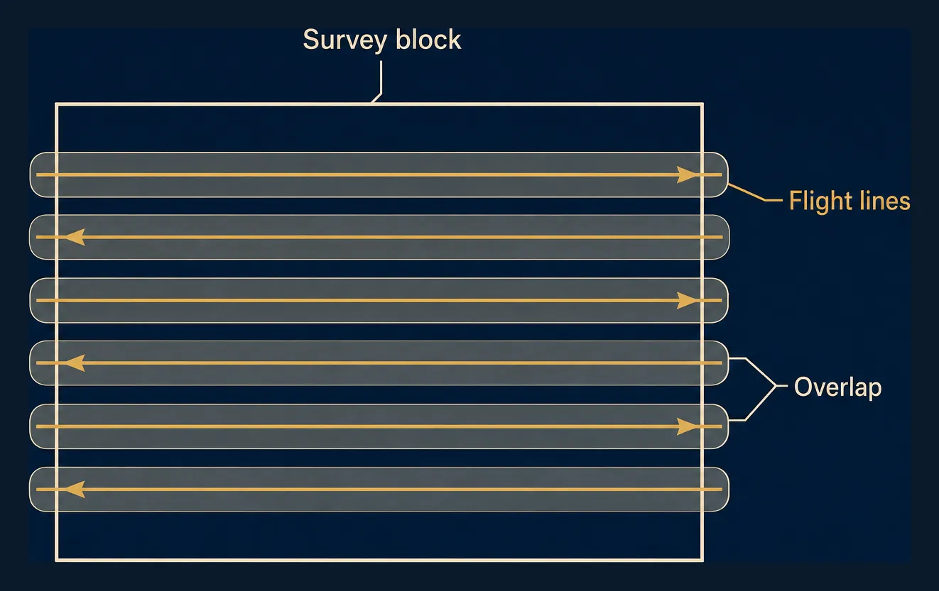
Coverage requirements translate directly into a flight pattern: a block area is flown in parallel, overlapping lines so nothing between them is missed; how much overlap is enough belongs to your data-quality specification.
Planning Considerations
Weather and Light
Survey work is more weather- and light-sensitive than transport flying. A passenger flight needs safe conditions; a survey flight also needs conditions in which the subject can be recorded. Low sun, shadow, haze, and flat light degrade imagery and observer performance, and some sensors have their own weather limits. Build slack into the schedule and expect it to be used; the Weather, Delays & Scheduling FAQ covers the general pattern.
Staging and Landing Sites
Long corridors rarely sit next to an airport. Operations stage from an airport or helipad near the corridor, and long missions may need refueling stops or a pre-arranged fuel cache. Heliports & Landing Zones explains what helicopters can and cannot use.
Lead Time
Build lead time into the project schedule, not around it. The operator needs time to plan the pattern, arrange staging and fuel, and handle equipment installation and approval. Corridor coordination adds its own line items: pipeline and utility operators may require notification or escort for low flights along their assets, and work near sensitive facilities or restricted airspace needs separate coordination. Some pipeline patrol is itself a regulated activity, with federal pipeline-safety rules setting how often a line must be inspected, which is why patrol work often runs to a fixed calendar rather than an ad-hoc booking. Treat those inspection intervals as fixed milestones and book against them.
Cost Factors
The cost structure is predictable. Flight hours are the core, and low-and-slow pattern work over a small area can consume more hours than a long direct leg. Repositioning matters when the aircraft is based far from your corridor; standby accrues while aircraft and crew wait on weather, your ground team, or a window in the light. Crew and equipment factors, a second observer seat or sensor installation, add further. The framework is in What a Charter Costs: Framework, Not Quotes.
When a Helicopter Is the Wrong Answer
For very large areas, a fixed-wing aircraft covers ground faster and usually at lower cost per square mile; the helicopter wins on detail and access, not acreage. For broad, repeatable coverage at moderate resolution, satellite imagery or a drone program may deliver the data. Missions requiring sustained low flight over densely populated areas can be impractical at any budget.
Frequently Asked Questions
How long does a survey flight take?
Longer than the map suggests. Coverage, not distance, sets the pace: a few miles of corridor inspected carefully, with orbits at points of interest, can fill a flight. Budget hours against the pattern, not the mileage.
Can I bring my own camera or sensor?
Handheld cameras used by a passenger are usually straightforward. Anything mounted to the aircraft is an airworthiness and approval question for the operator, arranged in advance.
What if weather cancels the survey window?
More often than on transport charters, because the mission needs recordable conditions, not just safe ones. Plan a reflight window up front and keep hard deadlines off the back of a survey day.
Related Charters
- Aerial Photography & Film: cinematic imagery rather than survey data.
- Real Estate & Land Inspection: aerial viewing of property for buyers and investors.
- Express Cargo & Courier: time-critical items moved inside the aircraft.
- Time-Critical & Priority Charters: when the schedule itself is the mission.
- Specialized & Utility Charters: how the working-platform charters differ and which one fits your job.