

Charter market
ChannelIslands
A Line of Islands Off Ventura, and No Road to Any of Them
Channel Islands National Park encompasses five remarkable islands and their ocean environment, and four of them run in a line some fifty miles long across the Santa Barbara Channel: Anacapa at the near end about a dozen miles off Oxnard, then Santa Cruz, the largest island in California, then Santa Rosa, then San Miguel where the channel opens on the Pacific. Santa Barbara Island lies alone, well to the southeast.
From the mainland they are a grey wall on the horizon, and from a boat you see the one you are going to. The group only exists as a group from the air: four islands, the water between them, the kelp on it and the shelf under it, in one view.
What the Crossing Assembles
Anacapa is three islets and an arch. A thin spine of rock in three pieces, a light at the east end and an arch off the point, the shape everyone knows and nobody sees whole.
The north shore of Santa Cruz is a cliff line with holes in it. Sea caves are cut into the base of it for miles, some large enough to run a boat into, and from above the run reads as one wall with the caves as dark punctuation along it.
Santa Rosa has grassland, canyons and Torrey pines, one of only two natural stands of the tree in the world, on the fog-drenched slopes above Bechers Bay. The other is four hundred miles down the coast.
San Miguel is the wind and the animals. Thousands of seals and sea lions breed and haul out along its isolated coast, and Point Bennett at the western end is, from height, a beach that appears to be moving.
The kelp canopy is the other half of the subject. Giant kelp lies on the surface in dark brown rafts along every lee shore, and it reads better from the air than from a boat deck: on the water you are in it, above it you see its edges. Shipping lanes, the platforms off the Santa Barbara coast and the whales in season cross the same water.
A Thousand Feet Is the Rule Here, Not the Request
Most scenic markets have an altitude convention; this one has a regulation. The marine sanctuary wraps roughly six nautical miles of water around every island, and its federal rules prohibit disturbing marine mammals or seabirds by flying motorized aircraft at less than 1,000 feet over the waters within one nautical mile of any Island, adding that failure to maintain that altitude over such waters is presumed to disturb marine mammals or seabirds. The presumption removes any argument about whether anything was disturbed. The park asks the same over the islands, stating that all aircraft must maintain a minimum 1000-foot altitude above land and sea surfaces within the park.
Plan for it rather than around it: a thousand feet is a poor height for one seal and a good one for reading a coastline, a cave line and a kelp bed at once, which is what this market is for. An operator offering to go lower is telling you how the rest of the flight will be run.
Nothing Lands on These Islands
The park states that islands can only be reached by boat and that private aircraft are not allowed to land within park boundaries. No charter puts you ashore. There is no pad, no permission to ask for and no arrangement to make.
The flight is a crossing and a circuit, never an arrival. That reverses most island markets, where a transfer is the point and the sightseeing arrives on the way in. Here the aircraft is a viewing platform for an hour or two, then it goes home.
Camarillo Is the Mainland End of Every Leg
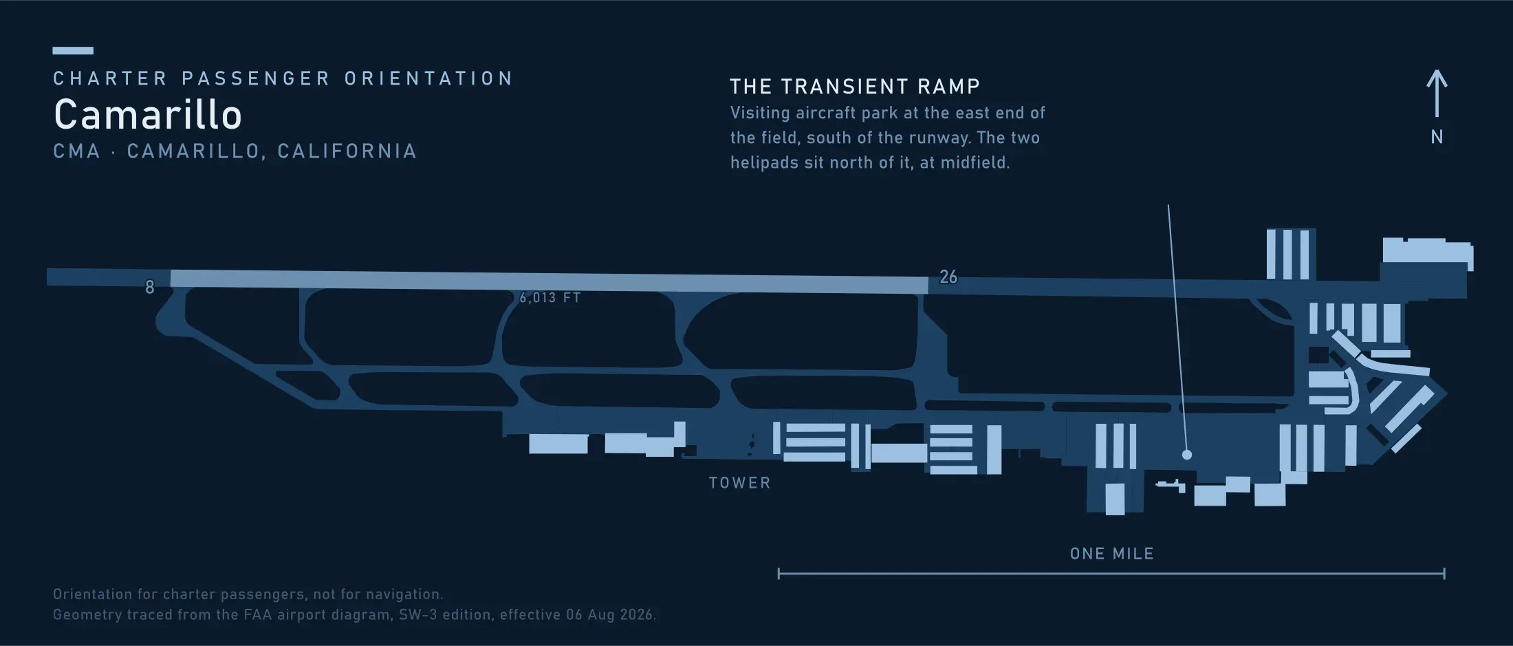
The field sits closest to the crossing and is built for it. Camarillo Airport is county-owned, open to the public, carries runway 08/26 at 6,013 by 150 feet, has a tower staffed 0700 to 2100, holds two 34 by 34 foot concrete heliports, and notes helicopter training pads north of taxiway B, a rotary presence most resort-country fields lack.
The constraint is noise. The field is an extreme noise sensitive area with a curfew prohibiting takeoffs between 0000 and 0500, and asks all jet and turbine aircraft to avoid flights between 10PM and 6AM local. A turbine helicopter sits inside that request, so an evening return is planned rather than assumed.
Santa Barbara and Oxnard both work, and both move a few minutes to one end of the channel. The water matters more than the field: every route here has an open-water leg, and open water narrows the class of machine and the number of engines before anything else.
The State With the Most Pads and None Where You Need One
The California page of the Heliport Atlas maps 388 registered heliports, the largest state record in the country, and not one of them open to the public.
The local breakdown says more. Ventura County holds thirteen, four of them hospital pads, and not one is on an island. Santa Barbara County holds nine, seven of them energy pads, which is to say the platforms out in the channel. The only helicopter infrastructure over this water belongs to oil and gas, so a landing happens at an airport and who owns and manages a site has one answer here.
When the Boat Is the Right Answer
If you want to stand on an island, take the boat. That is not a caveat, it is the whole comparison. The park’s own transport lands you there, runs year round, costs a fraction of an aircraft hour and gives you a day ashore no charter offers at any price.
Sea state is the other half. The crossing is exposed, and people book a helicopter to avoid a rough ride only to find the same weather is why the aircraft is not going either.
What a flight earns is narrower and real: the whole group in one pass, a fixed hour rather than a sailing schedule, and any job whose subject is the water rather than the ground.
Typical Routes and Flight Times
The four-island run. Out along the north shore of Santa Cruz, down Santa Rosa, round Point Bennett and home, the better part of two hours of scenic and sightseeing work done at height.
The Los Angeles leg. In from the basin fields to Camarillo or Santa Barbara, an hour of freeway compressed into a short flight of ordinary airport transfer work.
What Hiring the Whole Aircraft Changes
You pick the island and the hour. A shared seat flies one fixed loop on a set clock. A whole aircraft goes to San Miguel because that is where the light is, or turns back at Santa Cruz because the outer channel has closed in.
You can hold for the marine layer. Fog burns off on its own schedule, and the difference between a wasted morning and a good afternoon is the freedom to move a departure, most of the arithmetic in what a charter costs.
Doors and seating are yours. Over water and against a bright surface that decides an entire photography and film job, and a shared cabin offers neither choice.
Seasonal Patterns
Late summer and autumn are the flying season. The marine layer thins from August, the channel is calmest, and visibility runs long enough to see the whole group from the near end.
Late spring and early summer are the fog. May and June put low cloud over the channel for days at a time, clear inland and solid over the water, the situation that moves a departure rather than cancelling a week.
Winter brings the clearest air and the worst sea. Storms come through in sequence and the gaps are sharp.
Wind is a year-round fact at the west end. San Miguel and the outer channel blow when Anacapa is calm, so the far island is the part of a route to decide first.
Which Charter Types Dominate Here
Scenic flying, honest when sold as the shape of an archipelago rather than a close look at an animal.
Coastal transfers, in from the basin and up the Southern California coast, the work that pays for most days out of Camarillo.
Survey and film work. Aerial survey of kelp canopy and shoreline runs to a schedule a boat cannot keep.
Related Pages
- Destinations: the other US charter markets.
- Big Sur Coastline: the other California coast market flown at a legal floor.
- San Diego & Coronado: the coast market at the far south end of the same channel.
- San Juan Islands: the other archipelago read in one pass.
- Key West & Dry Tortugas: the other chain where open water picks the aircraft.
- Helicopter Class Comparison: what an over-water leg asks of the machine.
- Weather, Delays & Scheduling: what a marine layer does to a departure.
- Heliports & Landing Zones: the permission a site needs.
Heliports near the Channel Islands
The FAA records 59 heliports within 50 miles of the Channel Islands in the current cycle. Not one is public use, so every landing here starts with the owner’s permission. Your operator makes that arrangement before the flight is confirmed.
Heliports only. Airports are a separate class of facility and are not counted here, and in many markets the charter itself works from one.