
Charter market
LakeTahoe
A Lake in a Closed Basin
Lake Tahoe lies in a fault basin between the Sierra crest and the Carson Range, about 22 miles long and 12 across, its surface near 6,225 feet and the second deepest water in the country beneath it. The state line runs down the middle: California holds the west and south shores, Nevada the east.
The basin is a bowl, and that governs the flying. Granite rises straight out of the water on the west side, with Desolation Wilderness behind it. The Carson Range walls the east and tops out above 10,800 feet at Freel Peak. Every road into the basin climbs a pass, and every road inside it follows the shoreline, because there is nowhere else to put one.
What a Flight Actually Reaches
Emerald Bay. The glacial bay at the southwest corner, holding Fannette Island, the lake’s only island, with Eagle Falls at its head.
The Desolation granite. Pyramid Peak and the Crystal Range behind the west shore: scoured rock and hundreds of small lakes in glacier-cut basins.
The west-shore shelf. Rubicon Point, where the bottom falls away a few hundred feet off the beach and the water turns green to black.
The east shore. Sand Harbor and the granite shallows north of it, where the lake reads pale over rock instead of navy over depth.
The Carson Range. The dry side: sage, Jeffrey pine and long open ridges standing above both the lake and the Carson Valley.
The north valleys. Martis Valley and Olympic Valley, the ski bowls above them, and the Truckee River at the lake’s only outlet.
Twelve Miles Across, and No Way Over
There is no bridge and no causeway. Two points on opposite shores sit twelve miles apart across the water and thirty or forty around it, on two-lane state highway carrying every visitor in the basin at once.
The weakest link in that ring is State Route 89 above Emerald Bay, a narrow shelf cut into the cliff face, and Caltrans closes it for snow, avalanche and slide often enough to plan around. When it shuts, the west shore becomes a dead end.
Reaching the basin is the same problem one scale up. Mount Rose Highway and Spooner Summit climb in from Nevada, US 50 and Interstate 80 from the Sacramento Valley, and a Sierra storm closes them in sequence. A winter airport transfer that reads as an hour on a map can run three, or fail.
Four Fields, Four Elevations
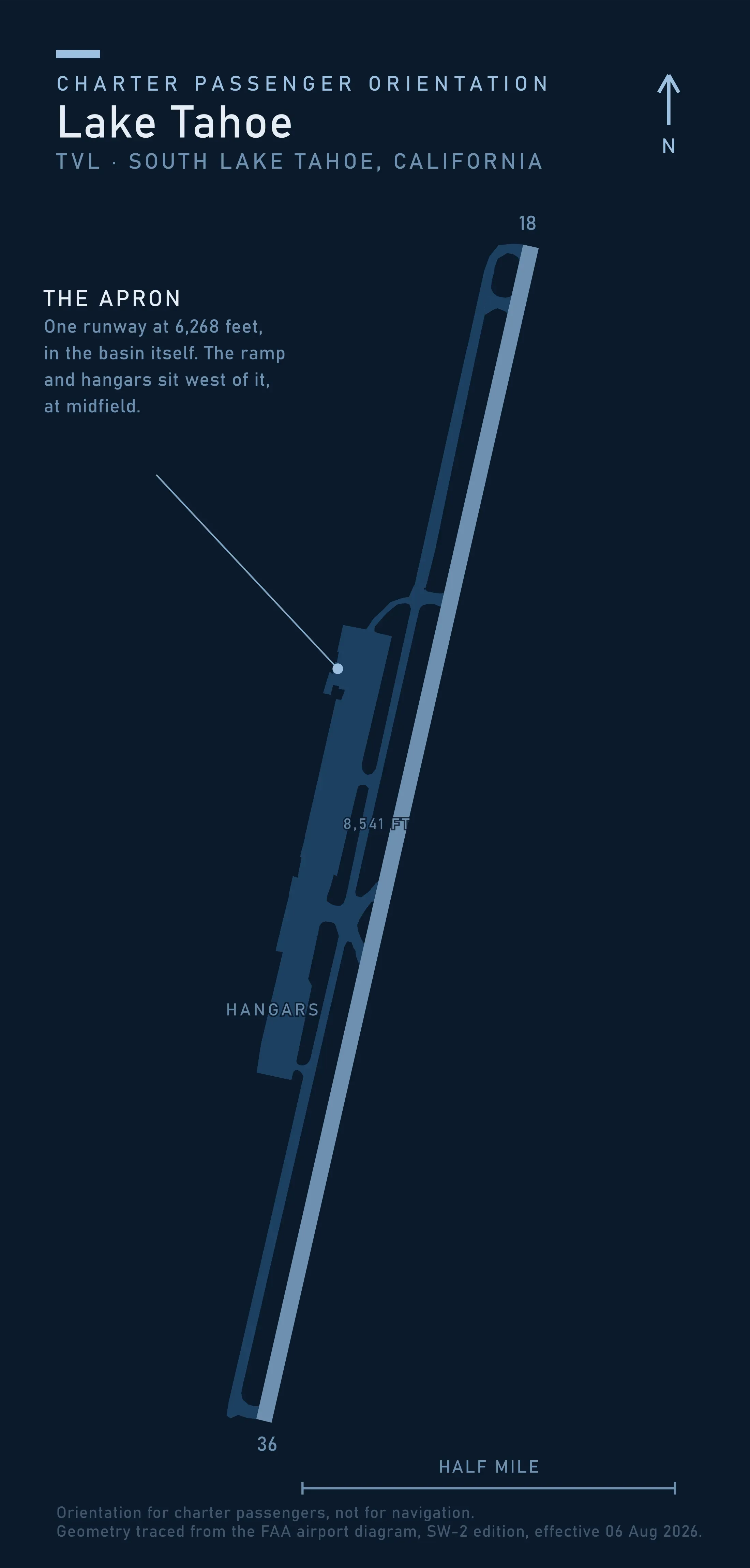
Lake Tahoe Airport is the only field inside the basin, a few miles from the south shore: one runway 18/36 at 8,541 by 100 feet, a published field elevation of 6,268 and no control tower.
Truckee Tahoe sits north of the basin in Martis Valley at 5,901 feet and takes most of the north shore’s traffic. Minden-Tahoe lies over the Carson Range in Nevada, lower and usually clearer. Reno-Tahoe International, at 4,415 feet, is the airline gateway and the field an arriving charter most often connects to.
Those elevations are performance numbers before they are anything else. Density altitude decides what an aircraft lifts out of here, exactly as it does across the Colorado passes, and it moves through the day: four adults with ski bags at eight in the morning can be three of them at three in the afternoon. Settle that load for the hour you actually depart.
For a helicopter the runway matters less than what exists on the ground, and the California page of the Heliport Atlas maps that. Setting down anywhere else in the basin depends on who owns and manages the site, which here means a regional agency as well as a landowner.
The Basin Sets Its Own Noise Limit
Almost every American market leaves aircraft noise to the FAA and the airport sponsor. Not this one. The Tahoe Regional Planning Agency holds a single-event standard for aircraft in the basin: a maximum of 80 dBA between eight in the morning and eight at night, and 77 dBA between eight at night and eight in the morning, measured at set distances from the takeoff roll and the approach threshold.
North of the lake, Truckee Tahoe asks pilots to keep a voluntary no-fly curfew between ten at night and seven in the morning and to route away from residential ground.
Neither writes the market off, and both are reasons to settle the schedule before you commit. The flying day has ends here, a late return is not something to assume, and which class of machine an operator offers is partly a noise answer.
Three Things Not Worth Flying
The lake surface. Ramps and marinas ring the shoreline, and a boat puts you on the water for an afternoon. Looking down on it is different, not an upgrade.
Desolation Wilderness, if the plan is to stand in it. It runs to 63,960 acres of granite and alpine lakes southwest of the lake, and travel inside it is on foot or horseback only. The Wilderness Act prohibits landing an aircraft there, the same statute that shapes flying at Aspen. Overfly it freely; arrive in it never.
Emerald Bay’s own ground. A road runs along the rim and a trail runs down to the water, so the most photographed place in the Sierra takes a car and a morning. From above it is a shape; from the trail it is a visit.
Typical Routes and Flight Times
The Reno leg. Over the Carson Range from the airline gateway to either shore, well under half an hour, standing in for a drive a storm can double or stop.
The shore circuit. South shore out past Emerald Bay, north along the west cliffs, across the top and down the Nevada side, flown as whole-aircraft scenic and sightseeing charter rather than as a seat on a shared flight.
The cross-lake hop. North shore to south shore, minutes against most of an hour of shoreline traffic.
The Sierra crossing. West over Echo Summit or Donner Pass toward Sacramento and the Bay Area, useful precisely when the interstate is under chain control.
The utility leg. Survey and inspection outside the wilderness boundaries.
What Hiring the Whole Aircraft Changes
You get the calm hour. The air over this lake is best early, before the afternoon wind sets up across twelve miles of open water. An aircraft you have hired leaves when that window opens; a shared flight leaves when its seats are full.
You choose the shore. With the Sierra crest in cloud, an hour can work the Nevada side instead of being cancelled.
A closed road stops mattering. If SR 89 shuts or a pass goes to chains while you are out, a hired aircraft can put you on the other shore or back at Reno.
The clock is yours. An hour bought here can circle one bay slowly or sit idle on permitted ground while you work, the distinction drawn in What a Charter Costs.
Seasonal Patterns
Winter is the busiest season and the least reliable one. Sierra storms arrive in trains and drop feet rather than inches, closing the passes and the Emerald Bay shelf as they go. The weeks that fill the basin are the weeks that move the flights, the argument in Weather, Delays & Scheduling.
Spring is runoff and mud. The high country stays buried into June and the water is cold enough that almost nobody is on it.
Summer mornings are dependable and afternoons are not. Convection builds over the crest and the wind gets up across the lake, so a circuit booked for four o’clock in July is a booking that moves.
Autumn is the quiet window. Cold settled air, aspen turning in Hope Valley and along the Truckee, and the traffic gone home.
Which Charter Types Dominate Here
Arrival legs, the core of the market: Reno to either shore in season, and the crossing between the two, working the way resort flying does anywhere else.
Short leisure trips out of the Bay Area and Sacramento, the weekend getaway over a range that turns most of a driving day into a short flight.
Scenic flying, honest when sold as the whole basin rather than as a low pass at Emerald Bay.
Utility work, year-round: aerial survey for forest health and fuels reduction, powerline patrol, and lakeshore property inspection.
Related Pages
- Destinations: the other US charter markets, one at a time.
- Southern California: the state’s other market, where a heliport network rather than the terrain sets the pattern.
- Napa Valley & Sonoma Coast: an hour west, and where a Sierra weekend usually starts or ends.
- Colorado Mountain Corridor: thin air and what an aircraft lifts, worked through in full.
- Telluride: the other market where the map lies about how far apart two places are.
- Scenic & Sightseeing Charters: how a whole-aircraft sightseeing flight is planned.
- Weather, Delays & Scheduling: what a Sierra forecast does to a booking.
- Heliports & Landing Zones: the permission a landing site needs before anyone flies to it.
Heliports near Lake Tahoe
The FAA records 14 heliports within 50 miles of Lake Tahoe in the current cycle. Not one is public use, so every landing here starts with the owner’s permission. Your operator makes that arrangement before the flight is confirmed.
Heliports only. Airports are a separate class of facility and are not counted here, and in many markets the charter itself works from one.